Plizio Visual Lab
Cerro Tontol

Weather…
Water temperature…
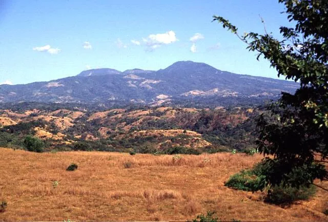
Cerro Tontol is a significant topographical elevation located in the San Miguel department of El Salvador, belonging to the complex mountainous landscape of the eastern region. Standing at an altitude of approximately 1,120 meters above sea level, the hill serves as a natural landmark for surrounding communities such as San Gerardo. The slopes of the mountain are covered with a mixture of pine-oak forests and deciduous woodlands, which are vital for local water catchment and biodiversity conservation. Geologically, Cerro Tontol is part of the country's older volcanic structures that predate the more active volcanic chain closer to the coast. The region has a long history of small-scale community agriculture, where the temperate climate at these heights provides favorable conditions for various crops. In recent years, the mountain has gained importance for eco-tourism, offering challenging hiking trails and expansive vistas over the Lempa River basin. It plays an essential role in regulating local temperatures and humidity in the immediate surrounding area, providing climatic stability. Its conservation is of strategic importance for the protection of local drinking water sources.
- Location: El Salvador
- Nearby: Jiquilisco (4 km)
Best time to visit & climate
The most pleasant time to visit is Jan, Nov, Dec.
| Jan | Feb | Mar | Apr | May | Jun | Jul | Aug | Sep | Oct | Nov | Dec | |
|---|---|---|---|---|---|---|---|---|---|---|---|---|
| Avg °C | 23 | 25 | 26 | 27 | 26 | 24 | 25 | 24 | 24 | 23 | 22 | 23 |
| Rain mm | 9 | 8 | 9 | 32 | 152 | 186 | 151 | 189 | 218 | 174 | 43 | 18 |
📋 Practical info
Geography
Facts
- The elevation reaches approximately 1,120 meters above sea level.
- It is located near San Gerardo in the San Miguel department.
- The slopes are covered in pine-oak and deciduous forests.
- Geologically, it belongs to an older volcanic formation of the area.
- It serves as a critical water catchment zone for local communities.
- The summit provides panoramic views of the Lempa River basin.
Explore nearby
Notable places around
Route planner — Car & Motorhome
Where do you start? We build the route here, with stops and country notes along the way.
© OpenStreetMap contributors · OpenRouteService
Sights nearby
Frequently asked questions
What characterizes Cerro Tontol?
Are there guided tours?
Is the summit suitable for children?
What is the best season?
Is parking possible there?
Cerro Tontol: where is it located?
Cerro Tontol: when is the best time to visit?
Cerro Tontol: why is it worth visiting?

Nearby cities


History & landmarks


Nature


More places