Plizio Visual Lab
Großer Beerberg
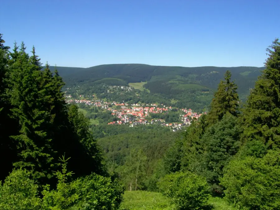
At an elevation of 982.9 meters, Großer Beerberg is the highest peak in the Thuringian Forest and a prominent landmark within the German central uplands. The mountain is of volcanic origin and consists primarily of rhyolite, which distinguishes its geological composition from the surrounding areas. The Rennsteig, Germany's most famous ridgeway trail, passes directly over the summit and attracts thousands of hikers annually. A unique feature is the raised bog at the peak, regarded as one of the best-preserved wetlands in the region and subject to strict nature conservation rules. From the Plattenbruch viewing platform, located near the actual summit, visitors can enjoy extensive panoramic views across the mountain range as far as the Rhön. Großer Beerberg also serves as a critical habitat for rare animal and plant species.
- Location: Thuringia, Germany
- Top sights: Kernzone Beerbergmoor · Großer Beerberg · Plänckners Aussicht
- Nearby: Zella-Mehlis (6 km)
Best time to visit & climate
The most pleasant time to visit is Jun–Aug.
| Jan | Feb | Mar | Apr | May | Jun | Jul | Aug | Sep | Oct | Nov | Dec | |
|---|---|---|---|---|---|---|---|---|---|---|---|---|
| Avg °C | -2 | -1 | 3 | 8 | 12 | 16 | 19 | 18 | 14 | 8 | 3 | 0 |
| Rain mm | 63 | 48 | 52 | 40 | 76 | 65 | 82 | 69 | 57 | 56 | 64 | 68 |
📋 Practical info
Geography
Facts
- 982.9 m: The exact official elevation of the highest point in Thuringia.
- Rhyolite: The volcanic rock that primarily composes the mountain massif.
- Rennsteig: The historic ridgeway trail passes directly through the summit region.
- Plattenbruch: Name of the prominent viewing platform located near the summit.
- UNESCO: Großer Beerberg is part of the core zone of the Thuringian Forest Biosphere Reserve.
- Raised bog: A rare and protected ecosystem located directly on the mountain peak.
Explore nearby
Notable places around
Route planner — Car & Motorhome
Where do you start? We build the route here, with stops and country notes along the way.
© OpenStreetMap contributors · OpenRouteService
Sights in the town Großer Beerberg (10)
Plänckners Aussicht
Viewpoint on Großer Beerberg, overlooking the Thuringian Forest.
Unterer Beerberg
Mountain in Germany, part of the Beerberg massif in the Thuringian Forest.
Aussichtsturm auf dem Schneekopf🗼 tower
Observation tower on Schneekopf near Gehlberg, panoramic views.
Schneekopf
Subpeak of Großer Beerberg in the Thuringian Forest, Thuringia.
Am Adler
Viewpoint in the Thuringian Forest, named after an eagle rock.
Teufelskanzel
Viewpoint with rock formation in the Thuringian Forest.
Kernzone Schneekopfmoor
Bog area at Schneekopf, protected natural zone.
Das Wasseredle im Pochwerksgrund
Waterfall or stream in Pochwerksgrund, Thuringian Forest.
Sights nearby
Frequently asked questions
How high is the Großer Beerberg?
Is there an observation tower on the summit?
Does the Rennsteig trail pass over the mountain?
Can you drive to the summit by car?
Is the mountain accessible in winter?
Großer Beerberg: where is it located?
Großer Beerberg: what is there to see?
Großer Beerberg: when is the best time to visit?
Großer Beerberg: why is it worth visiting?

Nearby cities