Plizio Visual Lab
Harz (Lower Saxony)
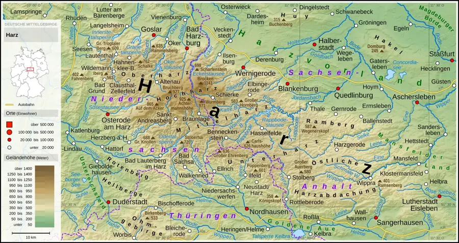
The Harz is Germany's northernmost low mountain range, extending across the federal states of Lower Saxony, Saxony-Anhalt, and Thuringia. The Lower Saxon portion is largely defined by the Harz National Park, established in 1994 to permanently protect the region's ancient spruce forests and bogs. The Brocken, at 1,141 meters, is the highest peak in the range and served as a strategically vital military site during the division of Germany due to its location. Historically, the region was characterized by centuries of mining, with the Rammelsberg ore mine in Goslar now designated as a UNESCO World Heritage site. The Harz Narrow Gauge Railways are a technical marvel, still transporting tourists to the Brocken summit using historic steam locomotives today. Geologically, the Harz consists of a complex structure of ancient rocks like granite and slate, shaped by millions of years of erosion. The range also acts as a critical water reservoir for Northern Germany, as demonstrated by numerous dams such as the Oker Dam.
- Location: Lower Saxony, Germany
- Top sights: Nationalpark-Besucherzentrum Brockenhaus · Aussichtsplattform über der Brockenherberge · Funkturm Brocken
- Nearby: Schierke (6 km)
Best time to visit & climate
The most pleasant time to visit is Jun–Aug.
| Jan | Feb | Mar | Apr | May | Jun | Jul | Aug | Sep | Oct | Nov | Dec | |
|---|---|---|---|---|---|---|---|---|---|---|---|---|
| Avg °C | 0 | 1 | 4 | 9 | 13 | 16 | 19 | 18 | 14 | 9 | 5 | 1 |
| Rain mm | 68 | 45 | 50 | 38 | 66 | 61 | 85 | 63 | 58 | 56 | 61 | 67 |
📋 Practical info
Geography
Facts
- The Brocken is the highest peak in Northern Germany at 1,141 meters.
- Harz National Park covers an area of 24,700 hectares.
- The Rammelsberg ore mine has been a UNESCO World Heritage site since 1992.
- The Harz Narrow Gauge Railways network covers about 140 km.
- The Oker Dam has a storage capacity of 47 million cubic meters.
- The last wild bear in the Harz was killed in the year 1718.
Explore nearby
Notable places around
Route planner — Car & Motorhome
Where do you start? We build the route here, with stops and country notes along the way.
© OpenStreetMap contributors · OpenRouteService
Sights in the town Harz (Lower Saxony) (10)
Brocken
Highest mountain of the Harz in Saxony-Anhalt, 1141 m.
Brockengarten
Alpine garden on the Brocken, accessible only by guided tour.
Teufelskanzel und Hexenaltar
Rock formations on the Brocken, associated with legends.
Torfstecherhütten
Ruins of peat cutters' huts in the bog.
Kleiner Brocken
Mountain in the Harz, near the Brocken.
Kahleklippe
Cliff near Wernigerode in the Harz.
Sights nearby
Frequently asked questions
How do you get to the Brocken?
Is it always windy on the Brocken?
What does the Brocken have to do with witches?
How high is the Brocken?
Was the Brocken accessible during the GDR era?
Harz (Lower Saxony): where is it located?
Harz (Lower Saxony): what is there to see?
Harz (Lower Saxony): when is the best time to visit?
Harz (Lower Saxony): why is it worth visiting?

Nearby cities