Plizio Visual Lab
Edersee
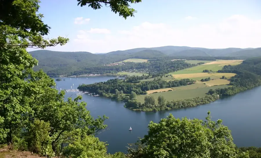
Lake Edersee in the Waldeck-Frankenberg district is one of Germany's largest reservoirs by surface area, with a capacity of nearly 200 million cubic meters. The Eder Dam was constructed between 1908 and 1914 to regulate water levels in the Weser River and the Mittelland Canal, as well as to provide flood protection. The imposing dam wall stands 47 meters high and 400 meters long; it was severely damaged by a British air raid during World War II and rebuilt shortly thereafter. Stretching approximately 27 kilometers in length, the lake is a major center for water sports and recreation in Northern Hesse. During periods of low water, the remains of sunken villages and the 'Asel Bridge' become visible, a phenomenon known as 'Edersee-Atlantis.' In addition to water management, the dam is used to generate environmentally friendly electricity through a hydroelectric power station at its base. The surrounding steep slopes are mostly forested and belong to the adjacent Kellerwald-Edersee National Park, providing the lake with a near-natural scenic backdrop.
- Location: Hesse, Germany
- Top sights: Weißer Stein · Loreley Klippe · Bringhäuser Brücke
- Nearby: Bad Wildungen (10 km)
Best time to visit & climate
The most pleasant time to visit is Jun–Aug.
| Jan | Feb | Mar | Apr | May | Jun | Jul | Aug | Sep | Oct | Nov | Dec | |
|---|---|---|---|---|---|---|---|---|---|---|---|---|
| Avg °C | -1 | 0 | 3 | 8 | 12 | 16 | 18 | 18 | 13 | 9 | 4 | 0 |
| Rain mm | 69 | 52 | 54 | 47 | 74 | 70 | 82 | 74 | 60 | 59 | 66 | 72 |
📋 Practical info
Geography
Facts
- Lake Edersee has a water surface area of about 11.8 square kilometers when full.
- The foundation stone for the dam wall was laid in the year 1908.
- The destruction of the dam in 1943 caused a flood wave up to 8 meters high.
- Three villages (Asel, Berich, and Bringhausen) were flooded to create the lake.
- The maximum depth of Lake Edersee is approximately 42 meters when full.
- The dam wall consists of about 300,000 cubic meters of quarry stone masonry.
Explore nearby
Notable places around
Route planner — Car & Motorhome
Where do you start? We build the route here, with stops and country notes along the way.
© OpenStreetMap contributors · OpenRouteService
Sights in the town Edersee (10)
Bericher Hütte
Ruins of a hut at the Edersee. Former shelter, now dilapidated.
Kletterwald
Climbing park at the Edersee. Courses in the trees for young and old.
Kahle Hardt
Hill in Germany. Elevation near the Edersee.
Denkmal Alt Bringhausen
Monument at the Edersee. Commemorates the sunken village of Bringhausen.
Kahle Haardt bei Scheid am Edersee
Protected area in Germany. Protected area near the Edersee.
Kahle Haardt
Viewpoint at the Edersee. Gives a panoramic view of the landscape.
Sights nearby
Frequently asked questions
How high is the Edersee dam?
Can you swim in Lake Edersee?
What is 'Edersee-Atlantis'?
How do I get to Waldeck Castle?
Are boats allowed on the lake?
Edersee: where is it located?
Edersee: what is there to see?
Edersee: when is the best time to visit?
Edersee: why is it worth visiting?

Nearby cities