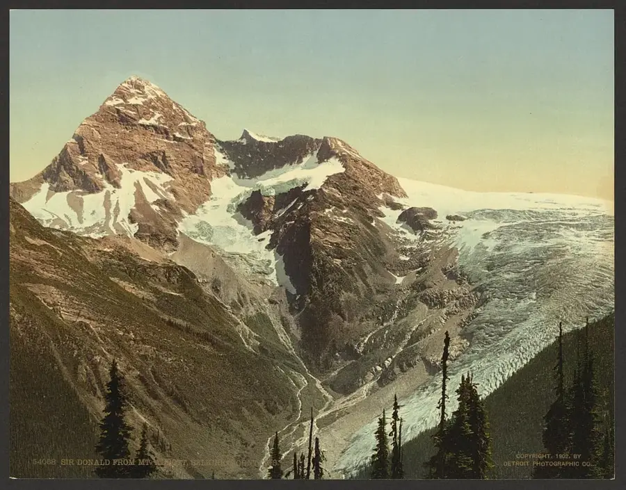
Plizio Visual Lab

Mount Sir Donald

Plizio editorial teamData Sources
Mountain
—°6
Mount Sir Donald (Canada)

Weather…

Mount Sir Donald is an iconic mountain peak in the Selkirk Mountains of southeastern British Columbia, serving as a centerpiece of Glacier National Park. Rising to an elevation of 3,284 meters, it dominates the skyline above Rogers Pass and is renowned for its striking pyramidal shape. The mountain is composed primarily of hard Precambrian quartzite, making it a premier destination for rock climbers, particularly via its classic Northwest Arête. The peak was named after Donald Smith, 1st Baron Strathcona and Mount Royal, a key figure in the completion of the Canadian Pacific Railway. The first successful ascent was made in 1890 by Emil Huber and Carl Sulzer, an event that heralded the golden age of mountaineering in Western Canada. Several glaciers cling to its steep slopes, including the Vaux Glacier, though they have receded significantly due to climate change. For those traveling the Trans-Canada Highway, Mount Sir Donald provides one of the most impressive alpine vistas in the country.

Best time to visit & climate

The most pleasant time to visit is Jun–Aug.

JanFebMarAprMayJunJulAugSepOctNovDec
Avg °C-12-12-8-43912116-1-9-14
Rain mm967199707610376618010311384

📋 Practical info

🧭
Getting there
Access typically begins from established trailheads within Glacier National Park, which visitors can usually reach by driving along the main highway routes through British Columbia.
📅
Best season
The optimal time for a visit is generally during the brief summer window when the snowpack is significantly reduced, though alpine weather can change unexpectedly even in mid-summer.
⛰️
Terrain & paths
The terrain surrounding this prominent pyramid-shaped peak is intensely rugged, featuring steep alpine paths, loose scree slopes, and extremely challenging sections meant for mountaineers.
🎒
What to bring
Visitors exploring the higher elevations must carry comprehensive alpine gear, including sturdy mountaineering boots, warm waterproof layers, and necessary safety equipment for mountain terrain.
🅿️
Parking
Parking is typically available at designated visitor centers or specific trailhead lots within the national park, but these spaces can fill up rapidly during the peak tourist season.
⚠️
Safety
Safety is a major concern due to the risk of sudden storms, avalanches in snowy conditions, and technical rockfall hazards; only experienced individuals should attempt the steeper routes.
⏱️
Time needed
While viewing the mountain from accessible lower trails might take just a few hours, any serious approach or climbing endeavor is typically a strenuous full-day or even multi-day expedition.

Geography

Coordinates
51.30000, -117.40000

Facts

  • The peak reaches an elevation of 3,284 meters.
  • The first ascent was achieved on September 3, 1890.
  • The Northwest Arête is ranked among the top 50 classic climbs in North America.
  • It is located within Glacier National Park, established in 1886.
  • The mountain is mainly composed of Hamill Group quartzite.
  • Donald Smith, the namesake, famously drove the 'Last Spike' of the CPR in 1885.

Explore nearby

Notable places around

Route planner — Car & Motorhome

Where do you start? We build the route here, with stops and country notes along the way.

Vehicle
Only stops with (optional):

© OpenStreetMap contributors · OpenRouteService

Sights in the town Mount Sir Donald (6)

Perley Rock🌿 nature

A peak in the Mount Sir Donald area, offering scenic views.

Mount Sir Donald🌿 nature

Mount Sir Donald is a prominent peak in the Selkirk Mountains of British Columbia.

North Terminal Peak🌿 nature

A summit in the Selkirk Mountains of British Columbia, part of the Illecillewaet Neve.

Rogers Pass Artillery Monument🏺 historical

A monument in the Mount Sir Donald area commemorating the role of artillery in the region.

Great Glacier House🏺 historical

The ruins of Great Glacier House, a historic building in the Mount Sir Donald area.

Red Chairs📍 landmark

Red Chairs are a popular attraction in the Mount Sir Donald area, known for their scenic location.

Sights nearby

Frequently asked questions

Where is Mount Sir Donald located?
In Glacier National Park in British Columbia.
Is it difficult to climb?
Yes, it is considered one of the classic technical climbs in Canada.
What is its characteristic shape?
A striking, steep rock pyramid towering over the Illecillewaet Valley.
How high is the mountain?
3,284 meters above sea level.
What is the most popular climbing route?
The Northwest Ridge is world-famous among mountaineers.
Mount Sir Donald: where is it located?
Mount Sir Donald is located in Canada.
Mount Sir Donald: what is there to see?
Highlights include Perley Rock, Mount Sir Donald, North Terminal Peak.
Mount Sir Donald: when is the best time to visit?
The most pleasant time to visit is Jun, Aug.
Mount Sir Donald: why is it worth visiting?
Mount Sir Donald is an iconic mountain peak in the Selkirk Mountains of southeastern British Columbia, serving as a centerpiece of Glacier National Park.
View on map → The Top 50 Attractions → OpenStreetMap →
North America
Explore with Plizio Discover more places in North America
More places in Canada →

Nearby cities