Plizio Visual Lab
San Andrés Island
Weather…
Water temperature…
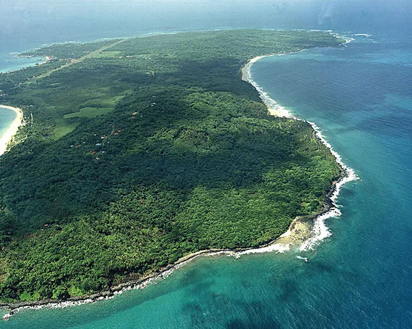
San Andrés is the largest island in the archipelago of San Andrés, Providencia, and Santa Catalina, located in the Caribbean Sea about 750 kilometers north of the Colombian mainland. It is widely celebrated for its 'Sea of Seven Colors,' a striking natural display of blue and green hues created by varying water depths and extensive coral reef formations. In 2000, the archipelago was designated by UNESCO as the Seaflower Biosphere Reserve, protecting one of the largest and most biodiverse marine ecosystems on the planet. The island's history is a unique blend of English, African, and Spanish influences, resulting in the distinct Raizal culture and the use of San Andrés Creole as a native language. Covering approximately 26 square kilometers, the island's landscape is characterized by limestone formations, with its highest point at La Loma reaching 85 meters. While tourism is the primary economic driver, San Andrés remains a vital ecological hub for monitoring Caribbean marine life, including sea turtles and hundreds of tropical fish species.
Explore on the map
How well do you know Colombia?
Find cities, landscapes and regions in 10 varied challenges on the interactive map.
Your journey, your memory
A postcard from San Andrés Island
Turn your own photo into a personal postcard with a local stamp. Free and no sign-up required.
Create a postcard- Location: Colombia
- Highlights: Casa Museo Isleña · Viewpoint La Loma · El Acuario
Best time to visit & climate
The most pleasant time to visit is Feb–Apr.
| Jan | Feb | Mar | Apr | May | Jun | Jul | Aug | Sep | Oct | Nov | Dec | |
|---|---|---|---|---|---|---|---|---|---|---|---|---|
| Avg °C | 27 | 27 | 27 | 27 | 28 | 28 | 28 | 28 | 28 | 28 | 28 | 28 |
| Rain mm | 32 | 10 | 7 | 20 | 112 | 162 | 150 | 144 | 162 | 229 | 221 | 79 |
📋 Practical info
Geography
Facts
- Famous for its 'Sea of Seven Colors' visual phenomenon.
- Declared a UNESCO Seaflower Biosphere Reserve in 2000.
- Located 750 km from mainland Colombia and 190 km from Nicaragua.
- The island occupies a land area of 26 square kilometers.
- Highest elevation is La Loma hill at 85 meters.
- The local Raizal community speaks a distinctive English-based Creole.
Explore nearby
Notable places around
Route planner — Car & Motorhome
Where do you start? We build the route here, with stops and country notes along the way.
© OpenStreetMap contributors · OpenRouteService
Sights in the town San Andrés Island (10)
Sights nearby
Frequently asked questions
What is the 'Sea of Seven Colors'?
What language do they speak there?
Do you have to pay an entry fee?
Can you go around the island?
Are there coral reefs?
San Andrés Island: where is it located?
San Andrés Island: what is there to see?
San Andrés Island: when is the best time to visit?
San Andrés Island: why is it worth visiting?