Plizio Visual Lab
Port of Itaqui
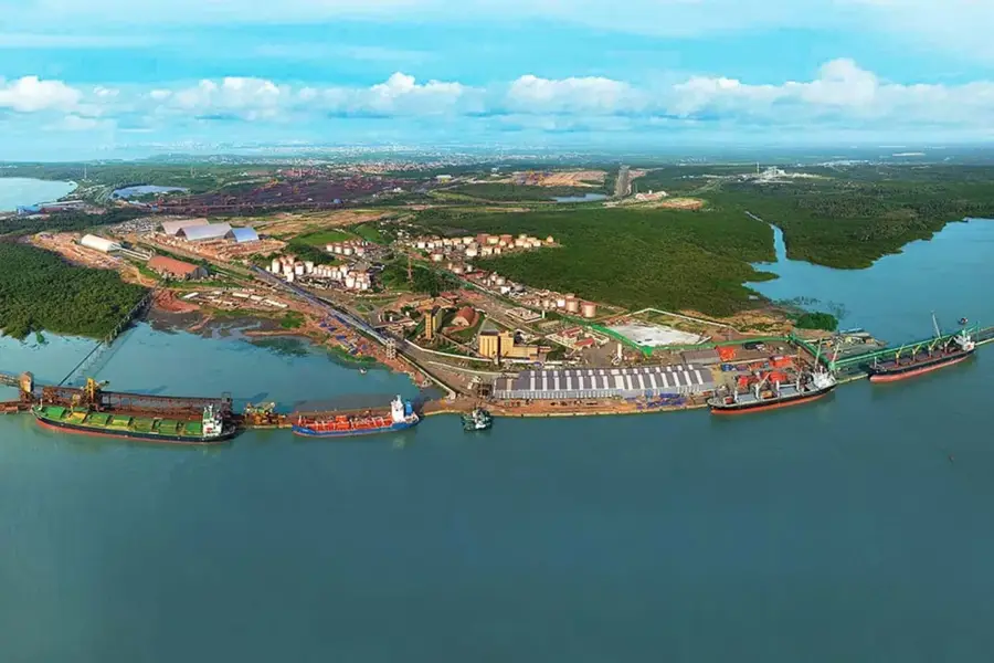
The Port of Itaqui, located in São Luís, is one of Brazil's deepest and most strategically important maritime hubs. With natural depths reaching up to 19 meters, it is capable of accommodating large Post-Panamax vessels at full capacity, making it a premier deep-water facility. It functions as the primary export gateway for the Northern Corridor, handling massive volumes of iron ore from the Carajás mines and agricultural commodities like soybeans and corn. Its geographic position on the Atlantic coast gives competitive transit times to markets in Europe and North America compared to southern Brazilian ports. Managed by EMAP, the port has evolved into a major logistics center for liquid fuels and bulk grains. The direct integration with the Carajás Railroad (EFC) is a critical factor in its high operational efficiency and cargo throughput. Recent expansions and modernization efforts have further increased its capacity to meet rising global demand for Brazilian raw materials.
Explore on the map
How well do you know Brazil?
Find cities, landscapes and regions in 10 varied challenges on the interactive map.
Your journey, your memory
A postcard from Port of Itaqui
Turn your own photo into a personal postcard with a local stamp. Free and no sign-up required.
Create a postcard- Location: Brazil
- Highlights: Ilha do Medo · Praia do Amor · Anfiteatro
Best time to visit & climate
The most pleasant time to visit is Aug, Oct, Nov.
| Jan | Feb | Mar | Apr | May | Jun | Jul | Aug | Sep | Oct | Nov | Dec | |
|---|---|---|---|---|---|---|---|---|---|---|---|---|
| Avg °C | 27 | 27 | 26 | 26 | 27 | 27 | 27 | 28 | 28 | 28 | 28 | 28 |
| Rain mm | 191 | 247 | 322 | 357 | 238 | 149 | 88 | 23 | 23 | 15 | 17 | 47 |
📋 Practical info
Geography
Facts
- Natural depth reaches up to 19 meters at its deepest berths.
- Directly linked to the 892 km long Carajás Railroad (EFC).
- Handles an annual cargo volume exceeding 30 million tons.
- Primary export hub for iron ore from the Carajás mining project.
- Managed by EMAP (Maranhão Port Administration Company).
- Major hub for the import and distribution of liquid fuels in Northern Brazil.
Route planner — Car & Motorhome
Where do you start? We build the route here, with stops and country notes along the way.
© OpenStreetMap contributors · OpenRouteService
Sights in the town Port of Itaqui (9)
Sights nearby
Frequently asked questions
Where is the Port of Itaqui located?
What makes Itaqui special?
What products are exported from here?
Is the port important for fuels?
Are there tourist tours in the port?
Port of Itaqui: where is it located?
Port of Itaqui: what is there to see?
Port of Itaqui: when is the best time to visit?
Port of Itaqui: why is it worth visiting?