Plizio Visual Lab
Kriebstein Baraj Gölü

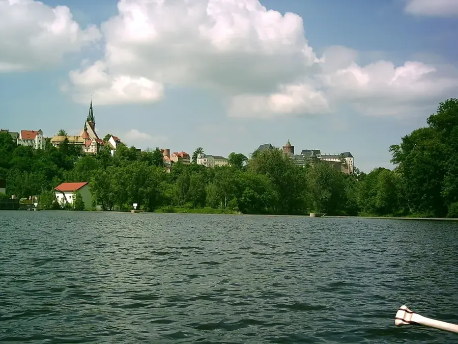
Talsperre Kriebstein, Zschopau nehrinin barajlanmasıyla oluşan Mittelsachsen ilçesindeki önemli bir su yönetimi yapısı ve dinlenme alanıdır. Baraj duvarı 1927 ile 1930 yılları arasında inşa edilmiş olup, öncelikle hidroelektrik enerjisi üretimi ve sel koruması amacıyla kullanılmaktadır. Yaklaşık 28 metre yüksekliği ve 230 metre kret uzunluğu ile nehri yaklaşık dokuz kilometrelik bir uzunlukta barajlar. Baraj gölü, dik kaya kıyıları ve yoğun ormanlarla şekillenen büyüleyici bir orta yükseklikte dağ manzarasının içine yerleşmiştir. Hemen yakınındaki özel bir kültürel vurgu, Sachsen'in en güzel şövalye kalesi olarak kabul edilen ve Zschopau üzerindeki bir kayanın üzerinde dik bir şekilde yükselen Burg Kriebstein'dır. Göl çevresindeki bölge yürüyüşçüler, su sporcuları ve balıkçılar için popüler bir destinasyondur; yolcu gemileri baraj gölü üzerinde düzenli turlar düzenlemektedir. Ayrıca baraj gölü, yaz aylarında eşsiz bir doğa dekoru önünde operet ve müzikal gösterilerinin sergilendiği Seebühne Kriebstein ile tanınır.
Haritada keşfet
Almanya hakkında ne kadar bilgilisin?
Etkileşimli haritada 10 çeşitli zorlukta şehirleri, manzaraları ve bölgeleri bul.
Seyahatin, senin anın
Kriebstein Baraj Gölü’den bir kartpostal
Kendi fotoğrafını yerel posta puluyla kişisel bir kartpostala çevir. Ücretsiz ve kayıt gerektirmez.
Kartpostal oluştur- Konum: Sachsen, Almanya
- Öne çıkanlar: Carolahöhe · Gerüstpfeilerviadukt · Schillerhöhe
- Yakınlar: Hartha (4 km)
En iyi ziyaret zamanı & iklim
En keyifli dönem: Haz–Ağu.
| Oca | Şub | Mar | Nis | May | Haz | Tem | Ağu | Eyl | Eki | Kas | Ara | |
|---|---|---|---|---|---|---|---|---|---|---|---|---|
| Ort. °C | -1 | 0 | 3 | 9 | 13 | 17 | 19 | 19 | 14 | 9 | 4 | 0 |
| Yağmur mm | 62 | 42 | 48 | 38 | 64 | 70 | 85 | 76 | 59 | 53 | 59 | 59 |
📋 Pratik bilgiler
Coğrafya
Gerçekler
- Baraj duvarının inşa süresi: 1927–1930.
- Baraj duvarının yüksekliği: yaklaşık 28 metre.
- Baraj gölü uzunluğu: yaklaşık 9 kilometre.
- Hidroelektrik santrali yeşil enerji üretmektedir.
- Yüzen bir göl sahnesine (Seebühne) ev sahipliği yapar.
- Tarihi Burg Kriebstein kalesine yakındır.
Yakınları keşfet
Çevredeki dikkat çekici yerler
Rota planlayıcı — Araba & Karavan
Nereden başlıyorsunuz? Burada rota oluşturuyoruz, yol boyunca duraklar ve ülke notları ile.
© OpenStreetMap contributors · OpenRouteService
Kasabadaki görülecek yerler Kriebstein Baraj Gölü (10)
AP Goldene Höhe
Kriebstein Gölü’ne panoramik bakışlar sunan seyir noktası.
Mehrgenerationenhaus Waldheim - Bergmann's Hof
Waldheim’de tarihi bir avluda kültür ve toplum merkezi.
Stadt- und Museumshaus🏛 müze
Waldheim’de yerel tarih müzesi, eski bir burjuva evinde yer alır.
Schlosskirche St. Otto
Waldheim Kalesi arazisindeki kilise, Romaesk kökenli.
Waldbühne
Bir zamanlar tiyatro gösterileri için kullanılan ormandaki açık hava sahnesi kalıntıları.
Viadukt Diedenmühle
Diedenmühle yakınındaki vadide uzanan taş kemerli demiryolu köprüsü.
Çevredeki gezilecek yerler
Sıkça sorulan sorular
Baraj gölünde tekne turları var mı?
Kriebstein baraj gölünde yüzebilir miyim?
Baraj gölü Kriebstein Kalesi'ne ne kadar uzakta?
Göl çevresinde yürüyüş parkurları var mı?
Baraj yakınında nerede park edebilirim?
Kriebstein Baraj Gölü: nerede yer alıyor?
Kriebstein Baraj Gölü: gezilecek yerler neler?
Kriebstein Baraj Gölü: en iyi ziyaret zamanı ne zaman?
Kriebstein Baraj Gölü: neden ziyaret edilmeye değer?

Yakındaki şehirler