Plizio Visual Lab
Walchensee
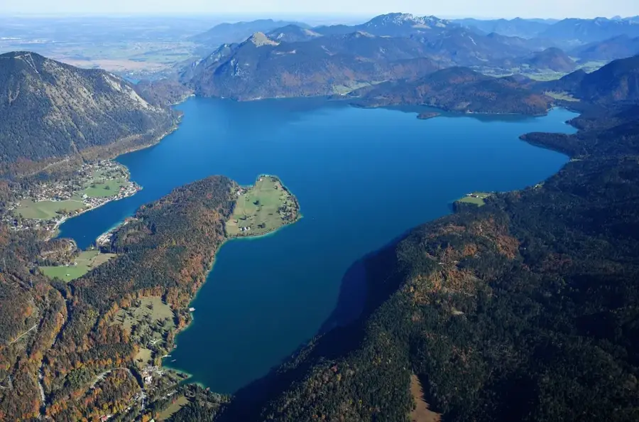
Walchensee, Almanya'nın en derin ve en büyük Alp göllerinden biridir ve Bayerische Voralpen'de 802 metre yükseklikte yer almaktadır. Maksimum 192 metre derinliği ve yaklaşık 16 kilometrekarelik yüzölçümü ile bölgenin önemli bir su kütlesidir. Gölün oluşumu tektonik çökmelere ve buzul çağı buzullarının aşındırma gücüne dayanmaktadır. 1924 yılından bu yana göl, Walchenseekraftwerk'in daha alçakta bulunan Kochelsee'ye olan kot farkından yararlanmasıyla yoğun bir şekilde enerji üretimi için kullanılmaktadır. Son derece berrak ve turkuaz renkli suyu nedeniyle göl genellikle 'Bavyera Karayipleri' olarak adlandırılır. Tarihsel olarak göl çevresi, 'Wickie ve Güçlü Adamlar'ın film uyarlaması da dahil olmak üzere çok sayıda film için set görevi görmüştür. Rüzgar koşulları gölü rüzgar sörfçüleri ve yelkenciler için de popüler bir bölge haline getirmektedir. Dik kıyıları ve Herzogstand gibi çevredeki dağlar belirgin manzara resmini şekillendirir. Bozulmamış doğayı korumak için tüm bölge peyzaj koruma altındadır.
Haritada keşfet
Almanya hakkında ne kadar bilgilisin?
Etkileşimli haritada 10 çeşitli zorlukta şehirleri, manzaraları ve bölgeleri bul.
Seyahatin, senin anın
Walchensee’den bir kartpostal
Kendi fotoğrafını yerel posta puluyla kişisel bir kartpostala çevir. Ücretsiz ve kayıt gerektirmez.
Kartpostal oluştur- Konum: Bayern, Almanya
- Öne çıkanlar: Insel Sassau im Walchensee · Herzogstand · Martinskopf
- Yakınlar: Kochel am See (8 km)
En iyi ziyaret zamanı & iklim
En keyifli dönem: Tem–Eyl.
| Oca | Şub | Mar | Nis | May | Haz | Tem | Ağu | Eyl | Eki | Kas | Ara | |
|---|---|---|---|---|---|---|---|---|---|---|---|---|
| Ort. °C | -4 | -3 | 1 | 6 | 10 | 14 | 15 | 15 | 11 | 7 | 2 | -3 |
| Yağmur mm | 83 | 65 | 81 | 84 | 149 | 175 | 172 | 185 | 119 | 91 | 70 | 74 |
📋 Pratik bilgiler
Coğrafya
Gerçekler
- Gölün maksimum su derinliği 192 metredir.
- Walchenseekraftwerk (Walchensee Elektrik Santrali) 1924 yılında işletmeye alınmıştır.
- Göl, deniz seviyesinden 802 metre yükseklikte yer almaktadır.
- Gölün su hacmi yaklaşık 1,3 milyar metreküptür.
- Gölün çevresi yaklaşık 27 kilometredir.
- Su sıcaklığı yazın nadiren 20 derecenin üzerine çıkar.
Yakınları keşfet
Çevredeki dikkat çekici yerler
Rota planlayıcı — Araba & Karavan
Nereden başlıyorsunuz? Burada rota oluşturuyoruz, yol boyunca duraklar ve ülke notları ile.
© OpenStreetMap contributors · OpenRouteService
Kasabadaki görülecek yerler Walchensee (7)
Çevredeki gezilecek yerler
Sıkça sorulan sorular
Walchensee neden böyle turkuaz renkte?
Walchensee rüzgâr sörfü için uygun mu?
Gölü en iyi hangi dağdan görürsünüz?
'Flake' film köyü nedir?
Walchensee ne kadar derindir?
Walchensee: nerede yer alıyor?
Walchensee: gezilecek yerler neler?
Walchensee: en iyi ziyaret zamanı ne zaman?
Walchensee: neden ziyaret edilmeye değer?

Yakındaki şehirler