Plizio Visual Lab
Klarälven
Weather…
Water temperature…
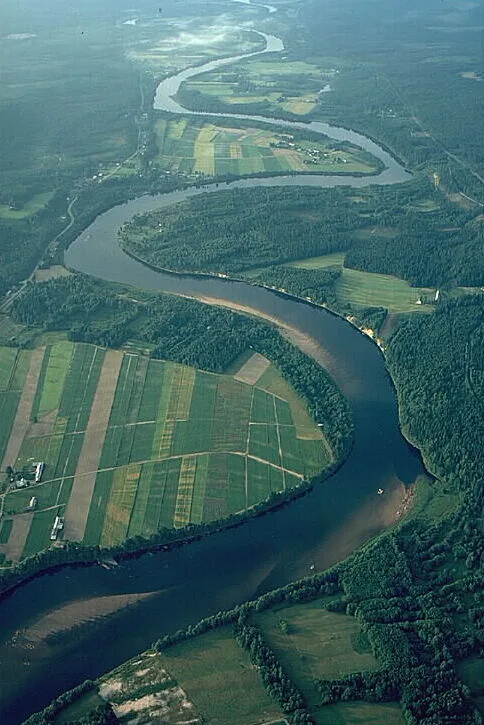
Klarälven is the longest river in Sweden and, together with the Norwegian Trysilelva, forms the longest river system in Scandinavia, totaling approximately 460 kilometers. It originates from Lake Femunden in Norway and flows through the province of Värmland before emptying into Lake Vänern at Karlstad. Historically, the river was of vital importance to the Swedish forestry industry, serving for centuries as the primary route for timber floating. This tradition continued until 1991, making Klarälven the last river in Sweden to support commercial log driving. The river is famous for its distinct meanders in its lower reaches, where it flows in wide loops through the valley, constantly reshaping the landscape. Ecologically, the river provides critical habitats for the endangered Klarälven salmon and brown trout. Today, the river is a popular destination for nature tourism, particularly for rafting trips on traditional timber rafts.
Explore on the map
How well do you know Sweden?
Find cities, landscapes and regions in 10 varied challenges on the interactive map.
Your journey, your memory
A postcard from Klarälven
Turn your own photo into a personal postcard with a local stamp. Free and no sign-up required.
Create a postcard- Location: Sweden
- Highlights: Kärnåsens hembygdsgård · Råda Stormosse
- Nearby: Arvika (64 km)
Best time to visit & climate
The most pleasant time to visit is Jun–Aug.
| Jan | Feb | Mar | Apr | May | Jun | Jul | Aug | Sep | Oct | Nov | Dec | |
|---|---|---|---|---|---|---|---|---|---|---|---|---|
| Avg °C | -6 | -5 | -1 | 5 | 10 | 14 | 16 | 15 | 11 | 5 | 0 | -4 |
| Rain mm | 69 | 54 | 49 | 52 | 91 | 101 | 112 | 113 | 76 | 90 | 82 | 69 |
📋 Practical info
Geography
Facts
- The total length of the river system is approximately 460 kilometers.
- At Karlstad, the river forms a delta consisting of eight main branches.
- Up to 19 million logs were floated down the river annually during peak years.
- Log driving officially ended on Klarälven in 1991, the last in Sweden.
- The river is home to a unique landlocked population of Atlantic salmon.
- The drainage basin of the river covers about 11,800 square kilometers.
Explore nearby
Notable places around
Route planner — Car & Motorhome
Where do you start? We build the route here, with stops and country notes along the way.
© OpenStreetMap contributors · OpenRouteService
Sights in the town Klarälven (2)
Sights nearby
Frequently asked questions
What is the most popular activity on the Klarälven River?
Where does the river flow?
Are there beavers there?
Can you fish in the river?
How fast does the water flow?
Klarälven: where is it located?
Klarälven: what is there to see?
Klarälven: when is the best time to visit?
Klarälven: why is it worth visiting?

Nearby cities