Plizio Visual Lab

Brattfallet
Plizio editorial teamData Sources
River
—°5
Brattfallet (Sweden)

Weather…

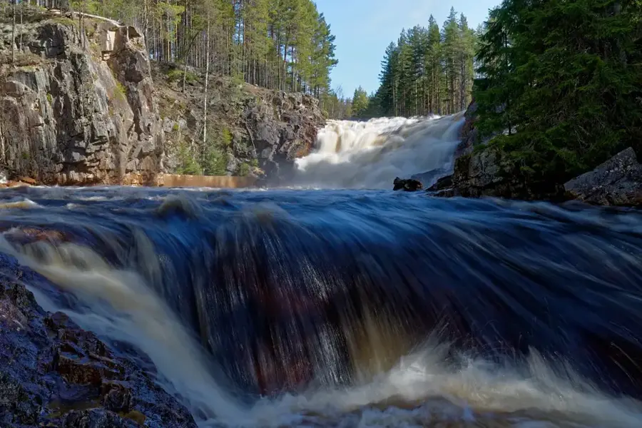
Brattfallet is a prominent waterfall in the province of Värmland, located on the Halgån River near the village of Ekshärad. Standing about 10 meters high, it is the centerpiece of a geologically significant canyon carved deep into the bedrock by meltwater erosion following the last ice age. A notable historical feature is the old stone arch bridge dating back to 1923, which spans the river directly above the falls and is a popular site for photography. The area was historically important for timber floating, and remnants of old wooden flumes used to bypass the rugged rocks are still visible today. A well-marked hiking trail, the Halgåleden, takes visitors through the gorge and provides spectacular viewpoints of the rushing water and the surrounding forest landscape. Brattfallet is especially powerful in the spring during the snowmelt, when the Halgån swells into a torrent, showcasing the raw power of nature's forces.

Explore on the map

How well do you know Sweden?

Find cities, landscapes and regions in 10 varied challenges on the interactive map.

Start the map quiz 10 challenges

Your journey, your memory

A postcard from Brattfallet

Turn your own photo into a personal postcard with a local stamp. Free and no sign-up required.

Create a postcard

Best time to visit & climate

The most pleasant time to visit is Jun–Aug.

JanFebMarAprMayJunJulAugSepOctNovDec
Avg °C-6-5-15101416151150-4
Rain mm695449529110111211376908269

📋 Practical info

🧭
Getting there
This highly photogenic and beautiful waterfall located in Värmland is generally very easily accessible directly via standard regional local roads. Short, well-maintained walking paths typically lead directly from the parking access points to the main gorge.
📅
Best season
Spring and early summer consistently usually offer the most visually impressive and powerful water volume immediately following the regional snowmelt. Autumn provides a truly exceptionally beautiful, colorful background scenery around the scenic Halgåån river.
⛰️
Terrain & paths
The immediate surrounding natural area features walking paths that carefully navigate tightly around the edges of the deep canyon-like gorge. The terrain can be quite unexpectedly uneven in places and often involves natural rocky steps leading down toward the river.
🎒
What to bring
Sturdy, firmly slip-resistant footwear with genuinely excellent traction is highly recommended when carefully walking near the rushing waterfall area. A good camera is practically universally essential to properly capture the highly impressive ten-meter drop.
🅿️
Parking
Convenient official parking spots are typically highly available just a very short walking distance from the main rushing waterfall viewing platforms. Space might sometimes be unfortunately limited during highly popular holiday weekends and peak summer seasons.
⚠️
Safety
Visitors must consciously exercise highly significant caution and closely supervise young children near the exceptionally steep, unprotected edges. The rocky surfaces directly surrounding the rushing waterfall are frequently very wet, mossy, and extremely slippery.
⏱️
Time needed
A genuinely brief, truly relaxing stop to simply view the immensely impressive ten-meter waterfall normally completely takes about one full hour. Visitors actively choosing to thoroughly explore the surrounding scenic river hiking trails often stay for half a day.

Geography

Coordinates
60.15000, 13.52000

Facts

  • The waterfall has a total drop of approximately 10 meters.
  • The historic stone bridge above the falls was completed in 1923.
  • Located within a gorge formed by glacial meltwater erosion.
  • Formerly a key site for timber floating operations on the Halgån.
  • Serves as the trailhead for the 7-kilometer Halgåleden hike.
  • Situated in the Torsby municipality in northern Värmland.

Explore nearby

Notable places around
Route planner — Car & Motorhome

Where do you start? We build the route here, with stops and country notes along the way.

Vehicle
Only stops with (optional):
Motorhome dimensions

© OpenStreetMap contributors · OpenRouteService

Sights in the town Brattfallet (5)

Ginbergsängen🌿 nature

A nature reserve near Brattfallet known for its untouched natural environment.

Ekshärads hembygdsgård📍 landmark

A local heritage museum in Brattfallet showcasing regional history and traditions.

Ekshärads kyrkstallar📍 landmark

Historic church stables in Brattfallet, once used by churchgoers.

Ekshäradspelaren🏺 historical

A monument in Brattfallet commemorating the local culture.

Mini golf📍 landmark

A mini golf course in Brattfallet offering recreation and entertainment.

Sights nearby

Frequently asked questions

Where exactly is Brattfallet located?
Near Ekshärad, in the province of Värmland.
How high is the waterfall?
The waterfall has a drop of about 10 meters.
Is there a bridge there?
Yes, an old stone bridge from 1923 spans the river.
Are there hiking trails?
Yes, there are three marked trails ranging from 1 km to 7 km in length.
Is the place suitable for children?
Yes, there are picnic areas and the short trails are easy to walk.
Brattfallet: where is it located?
Brattfallet is located in Sweden.
Brattfallet: what is there to see?
Highlights include Ginbergsängen, Ekshärads hembygdsgård, Ekshärads kyrkstallar.
Brattfallet: when is the best time to visit?
The most pleasant time to visit is Jun, Aug.
Brattfallet: why is it worth visiting?

Brattfallet is a prominent waterfall in the province of Värmland, located on the Halgån River near the village of Ekshärad.
View on map → The Top 50 Attractions → Most beautiful beaches → OpenStreetMap →
Europe
Explore with Plizio Discover more places in Europe
More places in Sweden →

Nearby cities

More places