Plizio Visual Lab
Santa Catalina Island
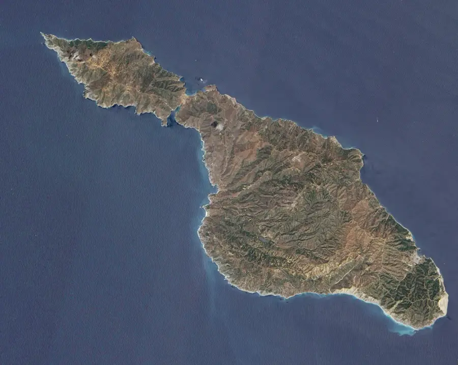
Santa Catalina Island, part of the rugged Channel Islands archipelago, sits approximately 22 miles south-southwest of Los Angeles across the massive San Pedro Channel. Unlike the heavily populated mainland, the island's geography is defined by incredibly steep, rocky hillsides, deep massive canyons, and a deeply rugged coastline completely devoid of massive sandy beaches. Historically heavily exploited for mining and smuggling, the island was deeply transformed in the 1920s by chewing gum magnate William Wrigley Jr., who initiated a massive conservation effort. Today, almost 90% of the massive landmass is completely protected by the Catalina Island Conservancy, preserving highly unique, endemic flora and fauna, notably the isolated Catalina Island fox.
- Location: United States
- Top sights: Toyon Bay · Mount Orizaba · Wrigley Botanical Gardens
- Nearby: Avalon (9 km)
Best time to visit & climate
The most pleasant time to visit is Jul–Sep.
| Jan | Feb | Mar | Apr | May | Jun | Jul | Aug | Sep | Oct | Nov | Dec | |
|---|---|---|---|---|---|---|---|---|---|---|---|---|
| Avg °C | 15 | 14 | 14 | 14 | 15 | 16 | 18 | 19 | 19 | 18 | 17 | 15 |
| Rain mm | 76 | 78 | 43 | 18 | 8 | 1 | 1 | 0 | 3 | 15 | 27 | 67 |
📋 Practical info
Geography
Facts
- Located 22 miles off the massive, highly urbanized Southern California coast.
- Features an incredibly rugged, massive topography rising to 2,097 feet.
- Nearly 90% of the massive island is strictly protected by a conservancy.
- Home to highly unique, deeply endemic species like the Catalina Island fox.
- William Wrigley Jr. initiated massive conservation efforts in the 1920s.
- Avalon is the only incorporated, heavily populated city on the island.
Explore nearby
Notable places around
Route planner — Car & Motorhome
Where do you start? We build the route here, with stops and country notes along the way.
© OpenStreetMap contributors · OpenRouteService
Sights in the town Santa Catalina Island (13)
Sights nearby
Frequently asked questions
How do I get to the island?
Are there bison there?
Can you drive a car?
Can you snorkel?
Do I need a hotel?
Santa Catalina Island: where is it located?
Santa Catalina Island: what is there to see?
Santa Catalina Island: when is the best time to visit?
Santa Catalina Island: why is it worth visiting?

Nearby cities