Plizio Visual Lab

Kodar Mountains
Plizio editorial teamData Sources
Mountain
—°
Kodar Mountains (Russia)

Weather…

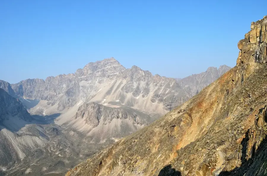
The Kodar Mountains form a captivating, highly inaccessible alpine region in the Russian Transbaikal territory, standing as the highest and most northeastern extension of the Stanovoy Highlands. With its exceptionally steep, deeply jagged granite and gneiss peaks, it presents an unexpectedly dramatic, purely alpine relief rising abruptly from the endless expanse of the Siberian taiga. A striking geological and climatic anomaly of the Kodar range is that it is the only mountain system in this part of Eastern Siberia to sustain genuine, albeit small, hanging glaciers. Among the region's absolute natural wonders are the Chara Sands, an extensive, bright yellow sand desert that lies in surreal juxtaposition directly at the foot of the snow-capped mountains, encircled by dense larch forests. Historically, the area harbors dark secrets: in the late 1940s, the extremely remote Borlag Gulag camp was established here, where prisoners mined the very first Soviet uranium for the atomic bomb program under inhumane conditions.

Explore on the map

How well do you know Russia?

Find cities, landscapes and regions in 10 varied challenges on the interactive map.

Start the map quiz 10 challenges

Your journey, your memory

A postcard from Kodar Mountains

Turn your own photo into a personal postcard with a local stamp. Free and no sign-up required.

Create a postcard

Best time to visit & climate

The most pleasant time to visit is Jun–Aug.

JanFebMarAprMayJunJulAugSepOctNovDec
Avg °C-29-27-18-911114113-9-22-29
Rain mm771439841021361197534158

📋 Practical info

🧭
Getting there
Access to Kodar Mountains is typically via regional roads leading to the nearest base settlements. Due to its remote nature in Russia, visitors generally rely on local transport networks or robust off-road vehicles to reach the starting points of mountain trails.
📅
Best season
The most favorable season to visit the Kodar Mountains region is during the brief summer months when the weather is generally milder. During this time, the rugged trails are typically clear of heavy snow, offering the safest conditions for exploring the elevated terrain.
⛰️
Terrain & paths
The terrain of Kodar Mountains features rugged slopes, uneven rocky paths, and significant elevation changes throughout the landscape. Hiking here can be physically demanding, requiring good fitness levels and careful navigation along the sometimes poorly marked trails.
🎒
What to bring
Visitors should absolutely bring sturdy hiking boots, layered windproof and waterproof clothing, and appropriate wilderness navigation tools. It is also essential to carry plenty of drinking water, emergency medical supplies, and sufficient high-energy snacks.
🅿️
Parking
Parking is usually available in the peripheral villages or designated base camps located at the lower foothills of Kodar Mountains. From these established access points, travelers typically proceed on foot or hire specialized local transport to venture deeper into the area.
⚠️
Safety
Safety concerns in Kodar Mountains include rapid weather changes, potential altitude exposure, and the extreme isolation of this region in Russia. Hikers must realistically assess their abilities, inform someone of their planned route, and stay strictly on paths.
⏱️
Time needed
A typical outdoor expedition into Kodar Mountains requires at least a full day, while comprehensive mountain treks can take several consecutive days to complete. The overall duration largely depends on the chosen trails, weather conditions, and personal fitness levels.

Geography

Coordinates
56.90000, 118.10000

Facts

  • Highest point is Pik BAM at 3,072 meters
  • Contains about 30 small mountain glaciers
  • Composed mostly of granite and gneiss
  • Part of the Stanovoy Highlands in East Siberia

Route planner — Car & Motorhome

Where do you start? We build the route here, with stops and country notes along the way.

Vehicle
Only stops with (optional):
Motorhome dimensions

© OpenStreetMap contributors · OpenRouteService

Sights nearby

Frequently asked questions

How difficult is hiking in the Kodar Mountains?
The terrain is alpine and very remote; experienced mountaineering and proper gear are mandatory.
What is the best time to visit the Kodar Mountains?
July and August are convenient, as the snow has melted and the weather is more stable.
Are there sanitary facilities or restaurants?
No, this is a completely untouched wilderness area with no infrastructure whatsoever.
What is the weather forecast like in the Kodar Mountains?
Weather is extremely changeable; sudden snowfalls can occur even in summer.
Do I have to pay a parking fee?
No, as there are no paved parking lots or accessible roads into the core zone.
Kodar Mountains: where is it located?
Kodar Mountains is located in Russia.
Kodar Mountains: when is the best time to visit?
The most pleasant time to visit is Jun, Aug.
Kodar Mountains: why is it worth visiting?

The Kodar Mountains form a captivating, highly inaccessible alpine region in the Russian Transbaikal territory, standing as the highest and most northeastern extension of the Stanovoy Highlands.
View on map → The Top 50 Attractions → OpenStreetMap →
Europe
Explore with Plizio Discover more places in Europe
More places in Russia →

Nearby cities