Plizio Visual Lab
Inírida
ℹ️Practical info — Inírida
▾
🌤 Weather — 5 days
📍 Nearby
Sights nearby
💡 Tips
- The main attraction, the Cerros de Mavecure, is only accessible by boat; book a tour with local indigenous guides.
- Motor-tricycles (tuk-tuks) are the most common way to get around town cheaply.
- Bring plenty of mosquito repellent and light, long-sleeved clothing for jungle excursions.
- Internet connectivity is extremely limited and slow, so download necessary offline maps and documents in advance.
🍽 Food
A traditional indigenous fish soup cooked with local chili peppers.
A crispy flatbread made from yuca (cassava), often eaten as a side dish.
Try this refreshing tropical fruit juice, similar to cacao.
🛍 Shopping · 🧘 Quiet spots
Buy woven baskets and clay pottery directly from local indigenous communities.
Early morning at the port is a great place to buy fresh exotic fruits.
Take a quiet boat ride to where the Guaviare, Atabapo, and Inírida rivers meet.
A serene, mystical lagoon great for bird watching and tranquility.
Water temperature…
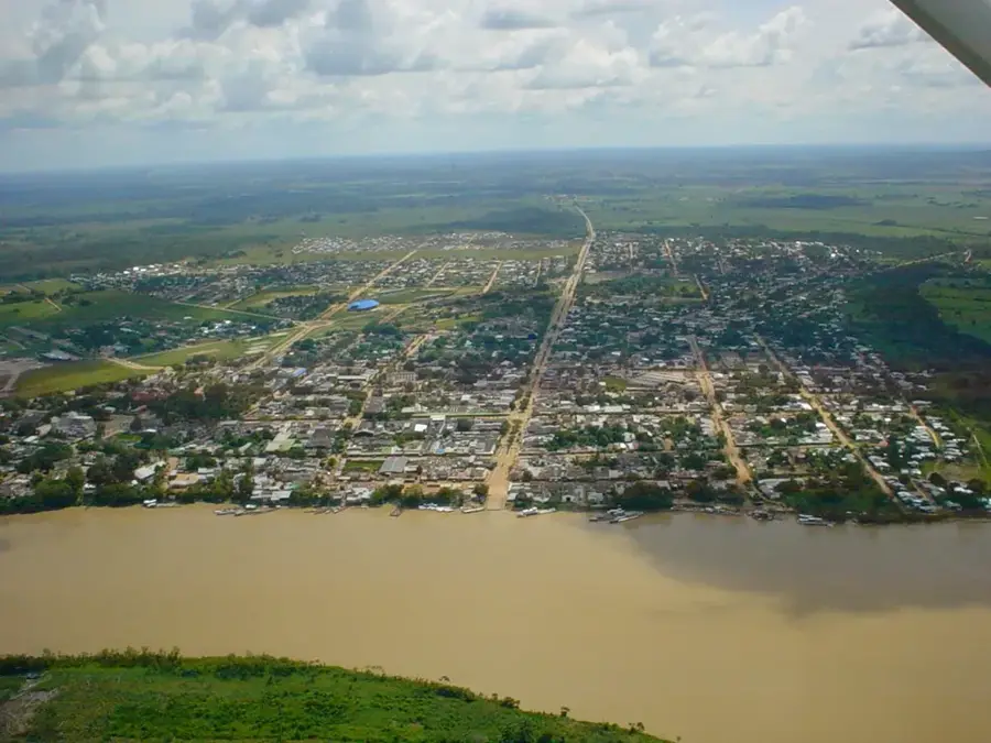
Inírida, the capital of the Guainía department in eastern Colombia, is a remote and enchanting city located near the border with Venezuela. Situated at the confluence of the Inírida and Guaviare rivers, the city is geographically isolated, with no road access to the rest of the country, making it reachable only by air or river transport. Founded in 1963 as Puerto Obando, it was later renamed Inírida, which means 'Little Mirror' in the local indigenous tongue. The region is part of the ancient Guiana Shield, and its landscape is famously marked by the Cerros de Mavecure, three massive granite monoliths that rise dramatically from the rainforest floor. These geological wonders are among the oldest formations on Earth and are a primary draw for eco-tourists. The population of Inírida is predominantly indigenous, with groups like the Puinave and Curripaco maintaining a strong presence and influencing the local culture and craftsmanship. The economy revolves around river trade, subsistence fishing, and a burgeoning eco-tourism sector that prioritizes environmental conservation. A unique botanical highlight of the area is the 'Flower of Inírida' (Schoenocephalium teretifolium), an endemic plant known for its striking appearance and durability. The climate is tropical and humid, characterized by heavy rainfall that sustains the surrounding dense jungle and complex river systems. As the administrative heart of Guainía, Inírida serves as a base for scientific research into the biodiversity of the Amazon-Orinoco transition zone. Despite its isolation, the city is slowly modernizing, striving to balance urban development with the protection of its invaluable natural and indigenous heritage, offering a glimpse into one of the most pristine corners of South America.
- Location: Colombia
- Top sights: Comunidad Indígena de Sabanitas · Iglesia del Divino Niño · Catedral de Nuestra Señora del Carmen
- Population: ~7.298 (2026)
Best time to visit & climate
The most pleasant time to visit is Jan, Feb, Dec.
| Jan | Feb | Mar | Apr | May | Jun | Jul | Aug | Sep | Oct | Nov | Dec | |
|---|---|---|---|---|---|---|---|---|---|---|---|---|
| Avg °C | 26 | 27 | 27 | 26 | 26 | 25 | 25 | 25 | 26 | 26 | 26 | 26 |
| Rain mm | 45 | 48 | 95 | 188 | 299 | 357 | 374 | 270 | 200 | 150 | 121 | 72 |
Geography
Facts
- Inírida was established in 1963 and became a capital in 1991.
- The city is only accessible by airplane or river boat.
- The Cerros de Mavecure consist of three peaks: Pajarito, Mono, and Mavecure.
- It serves as the administrative seat of the Guainía department.
- The local flora includes the unique and endemic Inírida flower.
- Average annual temperature is around 28°C (82°F).
- The city is located at the confluence of several major rivers.
- It is a key center for indigenous culture and traditional crafts.
Explore nearby
Notable places around
Route planner — Car & Motorhome
Where do you start? We build the route here, with stops and country notes along the way.
© OpenStreetMap contributors · OpenRouteService
Sights in the town Inírida (3)
Frequently asked questions
What is the main highlight of Inírida?
How do you get there?
Is a yellow fever vaccine required?
Which rivers meet here?
Are there hotels in Inírida?
Inírida: where is it located?
Inírida: what is there to see?
Inírida: when is the best time to visit?
Inírida: why is it worth visiting?